Ponciau
| Ponciau | |
|---|---|
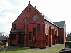
 Bethel Chapel, Ponciau |
|
| Ponciau shown within Wrexham | |
| OS grid reference | SJ294467 |
| Community | |
| Principal area | |
| Country | Wales |
| Sovereign state | United Kingdom |
| Post town | WREXHAM |
| Postcode district | LL14 |
| Dialling code | 01978 |
| Police | North Wales |
| Fire | North Wales |
| Ambulance | Welsh |
| EU Parliament | Wales |
| UK Parliament | |
| Welsh Assembly | |
Ponciau is a village within the community of Rhosllannerchrugog, Wrexham, Wales. It is close to the villages of Legacy, Pentre Bychan and Johnstown and is overlooked by Ruabon Mountain. The ward population at the 2011 Census was 4,842.
The Welsh word 'ponc' means bank or hillock and the village takes its name from the large number of spoil tips which formerly covered the area. Ponciau grew up around opencast mining and houses were built, with little regard for planning, to house the workers. At Brynydd, close to the Royal Oak public house, was the former site of typical very basic, one room, terraced, workers' houses. Tin baths were kept to the rear of the houses for bathing. Iron was also worked, with large furnaces in use at Furnace Bank.
Ponciau and Rhosllannerchrugog previously had more than 150 public houses but the majority of those have closed. The Colliers Arms, Horse & Jockey and Royal Oak still remain. One of the main streets in Ponciau is Chapel Street which once contained a large number of nonconformist chapels, reflecting the importance of religion in the village in former times. Several chapels remain. Many of the old buildings in the village are made from distinctive red bricks, from the Ruabon Brick and Terracotta Company.
Ponciau ward has one of the largest populations (4,486) of Wrexham County Borough. The ward is described as 'The Ponciau North, Ponciau South and Rhos wards of the Community of Rhosllannerchrugog and the Aberoer and Pentrebychan wards of the Community of Esclusham' in the OPSI document Statutory Instrument 1998 No. 3142. 29% of households do not own a car. A section of the ward boundary follows the path of the River Clywedog. Most map sites such as Multimap do not show Ponciau, but do generally show Rhosllannerchrugog.
...
Wikipedia

