San Fabian
| San Fabian | ||
|---|---|---|
| Municipality | ||

Poblacion
|
||
|
||
 Location in the province of Pangasinan |
||
| Location within the Philippines | ||
| Coordinates: 16°09′N 120°27′E / 16.150°N 120.450°ECoordinates: 16°09′N 120°27′E / 16.150°N 120.450°E | ||
| Country |
|
|
| Region | Ilocos (Region I) | |
| Province | Pangasinan | |
| District | 4th district of Pangasinan | |
| Founded | March 21, 1717 | |
| Barangays | 34 | |
| Government | ||
| • Mayor | Constante Batrina Agbayani | |
| • Vice Mayor | Leopoldo Manalo | |
| • Electorate | 46,269 voters (2016 election) | |
| Area | ||
| • Total | 81.28 km2 (31.38 sq mi) | |
| Population (2015 census) | ||
| • Total | 83,025 | |
| • Density | 1,000/km2 (2,600/sq mi) | |
| Time zone | PST (UTC+8) | |
| ZIP code | 2433 | |
| 015533000 | ||
| Dialing code | +63 (0)75 | |
| Income class | 1st municipal income class | |
| Revenue | ₱ 17,372,579.11 (2016) | |
| Poverty incidence | 11.65 (2012) | |
| Website | www |
|
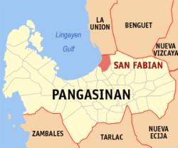
San Fabian (Pangasinan: Baley na San Fabian; Ilocano: Ili ti San Fabian) is a 1st class municipality in the province of Pangasinan, Philippines. According to the 2015 census, it has a population of 83,025 people and land area of 8,129 hectares.
The town used to be called Angio, and had been a mission territory of friars of the Dominican Order during the Spanish era. It is named after Saint Fabian who was a pontiff and saint of the Roman Catholic Church.
Around 1818 San Fabian had a boundary dispute with Mangaldan. The boundary between the two towns was the Angalacan river, which sometimes overflows because of floods. The boundary dispute was settled in 1900, when the mayor of San Fabian agreed to meet the mayor of Mangaldan and the two reached an agreement with a boundary marker being erected at Longos between the towns of San Fabian and Mangaldan. The agreement was signed by Juan Ulanday, Nicolas Rosa, Vicente Padilla, Marcelo Erfe, and approved by the American Commander Capt. Ferguson.
During the Philippine–American War hundreds of Pangasinense soldiers and soldiers of the Philippine government died in San Fabian battling the Americans After the pacification of Pangasinan by the United States the first town President of San Fabian was Ińigo Dispo. In 1903 the town of Alava became a part of San Fabian and became a mere village or barrio.
During World War II, the liberation of US Naval and Marine forces in Pangasinan started when troops under Gen. Walter Krueger landed on Lingayen, Mangaldan and San Fabian beaches. San Fabian landing zones were called White and Blue beaches, names which continue until the present time.
In October 2009, San Fabian was among the places heavily affected by the floods caused by the release of water by the San Roque Dam at Rosales during the height of the Typhoon Pepeng.
On October 13, 2012, the Kapisanan ng mga Brodkaster ng Pilipinas (KBP)-Pangasinan Chapter initiated a tree-planting activity, “broadcastreeing” which covered 10 barangays (Alacan, Cayanga, Guilig, Longos, Mabilao, Poblacion, Rabon, Tempra, Tiblong and Tocok). The Department of Labor and Employment (DOLE-1) released P495,000 as livelihood assistance to 30 farmers of the San Fabian Dairy Association.
...
Wikipedia


