Scarborough City Centre
| Scarborough City Centre | |
|---|---|
| Neighbourhood | |

Buildings at the Scarborough City Centre
|
|
 |
|
| Coordinates: 43°46′22″N 79°15′27″W / 43.77278°N 79.25750°WCoordinates: 43°46′22″N 79°15′27″W / 43.77278°N 79.25750°W | |
| Country |
|
| Province |
|
| City |
|
| Community | Scarborough |
| Changed Municipality | 1998 Toronto from |
| Government | |
| • MP | Salma Zahid (Scarborough Centre) |
| • MPP | Brad Duguid (Scarborough Centre) |
| • Councillor | Glenn De Baeremaeker (Ward 38 Scarborough Centre) |
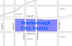
Scarborough City Centre is a city centre in Toronto, Ontario, Canada. Once considered a central business district for the former city of Scarborough, which was amalgamated with the rest of Toronto in 1998, the city centre remains as one of the major commercial districts outside of Downtown Toronto.
It is roughly bounded by Kennedy Road to the west, Markham Road to the east, Ellesmere Road to the south, and Sheppard Avenue to the North, spanning the official neighbourhoods of Bendale, Agincourt, and Woburn. At its core is the Scarborough Civic Centre (including Albert Campbell Square), Scarborough Town Centre, the Canada Centre (Government of Canada), the Scarborough Centre rapid transit station, and the Scarborough Centre Bus Terminal.
Condominium towers surround these central buildings and public spaces, forming the skyline. The major office towers in the area are those at Consilium Place, which was completed in 1991. In a band around the southern side of the city centre are densely forested parklands, between Borough Drive and Ellesmere Road. Outside the immediate city centre is mostly industrial parks and low-density housing.
...
Wikipedia
