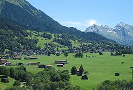
Serneus
| Klosters-Serneus | ||
|---|---|---|

Klosters Dorf
|
||
|
||
| Coordinates: 46°53′N 9°53′E / 46.883°N 9.883°ECoordinates: 46°53′N 9°53′E / 46.883°N 9.883°E | ||
| Country | Switzerland | |
| Canton | Graubünden | |
| District | Prättigau/Davos | |
| Area | ||
| • Total | 219.83 km2 (84.88 sq mi) | |
| Elevation () | 1,200 m (3,900 ft) | |
| Population (Dec 2015) | ||
| • Total | 6,177 | |
| • Density | 28/km2 (73/sq mi) | |
| Postal code | 7250 Klosters-Platz 7252 Klosters-Dorf 7249 Serneus |
|
| SFOS number | 3871 | |
| Surrounded by | Conters im Prättigau, Davos, Gaschurn (AT-8), Langwies, Lavin, Saas im Prättigau, Sankt Gallenkirch (AT-8), Susch | |
| Website |
www SFSO statistics |
|
Klosters is a town in the Prättigau/Davos Region in the Swiss canton of Graubünden. Together with neighbouring Serneus, the two towns form the municipality of Klosters-Serneus.
Its ski resort lies 150 km (93 mi) from Zurich, the nearest international airport. Transfer time is about 1.5 hours. Klosters is 10 km (6.2 mi) from Davos. It is a popular ski location and the slopes are easily accessible via a large cable car.
Klosters-Serneus is first mentioned in 1222 as ecclesiam sancti Iacobi. In 1436 it was mentioned as zuo dem Closter.
Klosters-Serneus has an area, (as of the 2004/09 survey) of 219.83 km2 (84.88 sq mi). Of this area, about 24.7% is used for agricultural purposes, while 19.5% is forested. Of the rest of the land, 1.6% is settled (buildings or roads) and 54.2% is unproductive land. In the 2004/09 survey a total of 179 ha (440 acres) or about 0.8% of the total area was covered with buildings, an increase of 33 ha (82 acres) over the 1985 amount. Over the same time period, the amount of recreational space in the municipality increased by 14 ha (35 acres) and is now about 0.08% of the total area. Of the agricultural land, 4 ha (9.9 acres) is used for orchards and vineyards, 954 ha (2,360 acres) is fields and grasslands and 4,797 ha (11,850 acres) consists of alpine grazing areas. Since 1985 the amount of agricultural land has decreased by 575 ha (1,420 acres). Over the same time period the amount of forested land has increased by 315 ha (780 acres). Rivers and lakes cover 289 ha (710 acres) in the municipality.
Before 2017, the municipality was located in and is the only municipality in Klosters sub-district of the Prättigau/Davos district, after 2017 it was part of the Prättigau/Davos Region. It was created in 1865 through the merger of the formerly independent municipalities of Serneus and Klosters. Until 1973 Klosters-Serneus was known as Klosters. It is the last and uppermost village in the Prättigau valley. It consists of the villages of Klosters and Serneus and is made up of the sections of Platz, Dorf, Selfranga, Äuja and Monbiel
Klosters-Serneus has a population (as of December 2015[update]) of 6,177. As of 2015[update], 19.7% of the population are resident foreign nationals. In 2015 a small minority (226 or 5.9% of the population) was born in Germany a small minority (286 or 7.5% of the population) was born in Portugal. Over the last 5 years (2010-2015) the population has changed at a rate of -2.43%. The birth rate in the municipality, in 2015, was 7.0, while the death rate was 9.2 per thousand residents. Most of the population (as of 2000[update]) speaks German (88.7%), with Portuguese being second most common (2.9%) and Serbo-Croatian being third (2.6%).
...
Wikipedia


