Sevier County, Arkansas
| Sevier County, Arkansas | |
|---|---|

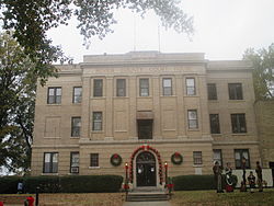
The Sevier County Courthouse is located in De Queen
|
|
 Location in the U.S. state of Arkansas |
|
 Arkansas's location in the U.S. |
|
| Founded | October 17, 1828 |
| Named for | Ambrose Hundley Sevier |
| Seat | De Queen |
| Largest city | De Queen |
| Area | |
| • Total | 581 sq mi (1,505 km2) |
| • Land | 565 sq mi (1,463 km2) |
| • Water | 16 sq mi (41 km2), 2.8 |
| Population (est.) | |
| • (2015) | 17,290 |
| • Density | 30/sq mi (12/km²) |
| Congressional district | 4th |
| Time zone | Central: UTC-6/-5 |
| Website | seviercountyar |
Sevier County is a county located in the U.S. state of Arkansas. As of the 2010 census, the population was 17,058. The county seat is De Queen. Sevier County is Arkansas's sixteenth county, formed on October 17, 1828, and named for Ambrose Sevier, U.S. Senator from Arkansas. It is an alcohol prohibition or dry county.
Sevier County was organized on October 17, 1828 under legislative authority. It was formed from Hempstead and Miller Counties. Five days later on October 22, 1818, the legislature expanded the county's border, incorporating more land south of the Red River. Hempstead, Miller and Crawford Counties as well as the Choctaw Nation in Indian Territory bound Sevier County. The establishment of Sevier County became effective on November 1, 1828.
The county seat has undergone several changes since Sevier County was organized. The first county seat was Paraclifta. In 1871, the Lockes donated 120 acres (0.49 km2) of land. As a result, the county seat was moved to Lockesburg. In 1905, the county seat was again moved to De Queen. Sevier County is known as “The Land of Lakes”, “The Land of Fruits and Flowers” and “The Home of Friendly People”. The county has five lakes within a 35-mile (56 km) radius, five rivers and mountain streams and forests.
According to the U.S. Census Bureau, the county has a total area of 581 square miles (1,500 km2), of which 565 square miles (1,460 km2) is land and 16 square miles (41 km2) (2.8%) is water.
As of the 2000 United States Census, there were 15,757 people, 5,708 households, and 4,223 families residing in the county. The population density was 28 people per square mile (11/km²). There were 6,434 housing units at an average density of 11 per square mile (4/km²). The racial makeup of the county was 79.61% White, 4.94% Black or African American, 1.82% Native American, 0.13% Asian, 0.06% Pacific Islander, 11.84% from other races, and 1.61% from two or more races. 19.72% of the population were Hispanic or Latino of any race. 17.32% reported speaking Spanish at home [1].
...
Wikipedia
