Singleton, Lancashire
| Singleton | |
|---|---|
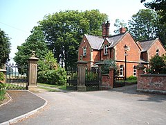
 Singleton Park Gatehouse |
|
| Singleton shown within Lancashire | |
| Population | 889 (2011 Census) |
| OS grid reference | SD380382 |
| Civil parish |
|
| District | |
| Shire county | |
| Region | |
| Country | England |
| Sovereign state | United Kingdom |
| Post town | POULTON-LE-FYLDE |
| Postcode district | FY6 |
| Dialling code | 01253 |
| Police | Lancashire |
| Fire | Lancashire |
| Ambulance | North West |
| EU Parliament | North West England |
| UK Parliament | |
Singleton is a village and civil parish in Lancashire, England. It is situated on the coastal plain called The Fylde. It is located south-east of Poulton-le-Fylde, and at the 2001 census had a population of 877, increasing to 889 at the 2011 Census. The parish is sometimes referred to as two parts – Great Singleton is the larger part containing the village, and Little Singleton is a small area north of the village bordering the River Wyre.
Singleton railway station once served the village as part of the Preston and Wyre Joint Railway. The station was situated west of the village, on the road to Blackpool.
Singleton's parish church is St Anne's, designed by Lancaster architect Edward Graham Paley and completed in 1861. It has been designated a Grade II listed building by English Heritage.
At the time of the Roman conquest of Britain in the 1st century AD, the area around Singleton was inhabited by a Celtic tribe called the Setantii. The village was recorded in the Domesday Book of 1086 as Singletun.
In 2011, drilling equipment was installed at Grange Hill, east of the village, to test for shale gas in the Bowland Shale Formation around 3 km below the surface. In 2013 Cuadrilla and Centrica made plans for hydraulic fracturing, commonly known as fracking, at the site.
...
Wikipedia

