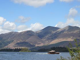
Skiddaw
| Skiddaw | |
|---|---|

|
|
| Highest point | |
| Elevation | 931 m (3,054 ft) |
| Prominence | 709 m (2,326 ft) |
| Listing | Marilyn, Hewitt, Wainwright, Nuttall |
| Coordinates | 54°38′49″N 3°08′46″W / 54.647°N 3.146°WCoordinates: 54°38′49″N 3°08′46″W / 54.647°N 3.146°W |
| Geography | |
| Parent range | Lake District, Northern Fells |
| OS grid | NY260290 |
| Topo map | OS Landrangers 89, 90, Explorer OL4 |
| Listed summits of Skiddaw | ||||
| Name | Grid ref | Height | Status | |
|---|---|---|---|---|
| Sale How | NY276286 | 666 metres (2,185 ft) | Nuttall | |
Skiddaw is a mountain in the Lake District National Park in England, where its 931-metre (3,054 ft) summit is the sixth-highest in England. It lies just north of the town of Keswick, Cumbria, and dominates the skyline in this part of the northern lakes. It is the simplest of the Lake District mountains of this height to ascend (as there is a well-trodden tourist track from a car park to the north-east of Keswick, near the summit of Latrigg) and, as such, many walking guides recommend it to the occasional walker wishing to climb a mountain. This is the first summit of the fell running challenge known as the Bob Graham Round when undertaken in a clockwise direction.
The mountain lends its name to the surrounding areas of "Skiddaw Forest", and "Back o' Skidda'" and to the isolated "Skiddaw House", situated to the east, formerly a shooting lodge and subsequently a youth hostel. It also provides the name for the slate derived from that region: Skiddaw slate. Tuned percussion musical instruments or lithophones exist which are made from the slate, such as the Musical Stones of Skiddaw held at the Keswick Museum and Art Gallery.
The Northern Fells make up a roughly circular upland area approaching 10 miles (16 km) in width. At the centre is the marshy depression of Skiddaw Forest, a treeless plateau, or valley, at an altitude of about 400 metres (1,300 ft); flowing outwards from here are the rivers that divide the area into three sectors. The south-western sector, between the Glenderaterra Beck and Dash Beck, contains Skiddaw and its satellites.
Skiddaw itself takes the form of a north-south ridge about half a mile long, with steep slopes to east and west. The ridge continues northwards over Broad End to Bakestall, a fell overlooking the Whitewater Dash waterfall. Further ridges fan out east and west from the southern end of Skiddaw. To the south-east are Skiddaw Little Man, Lonscale Fell and Latrigg, an easily accessible viewpoint for Keswick and Derwentwater. Beyond these fells are the Glenderaterra Beck and the Blencathra group. The south-western ridge curves round through 180 degrees to run north above the shore of Bassenthwaite Lake. This gives Skiddaw an "outer wall", comprising Carl Side, Long Side and Ullock Pike, collectively referred to as Longside Edge. The final member of the Skiddaw Group is Dodd, a satellite of Carl Side.
...
Wikipedia

