Snaefell Mountain Course
 |
|
| Location | Douglas, Isle of Man |
|---|---|
| Time zone | GMT |
| Major events | Isle of Man TT, Manx Grand Prix |
| Length | 60.725 km (37.733 mi) |
| Turns | 200+ |
| Lap record | 16 minutes 53.929 seconds — 133.962 mph (215.591 km/h) (Michael Dunlop, BMW, 2016) |
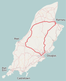
Snaefell Mountain Course or Mountain Course is a road-racing street circuit used for the Isle of Man TT since 1911 and Manx Grand Prix races from 1923 in the Isle of Man. The motorcycle racing is held on public roads closed for racing by an Act of Tynwald (the parliament of the Isle of Man) under the Road Racing Act (Isle of Man) 1982 and the Road Traffic Regulation Act (Isle of Man) 1985. It is the oldest motor-cycle racing circuit still in use. It is also one of the deadliest, with 6 deaths in 2011, 5 in 2014 and 248 cumulatively by 2015, of racers in competition. There have been 14 deaths of officials, spectators, and others.
The clockwise course is 37.73 miles (60.72 km) in length from the start-line at the TT Grandstand situated on the A2 Glencrutchery Road in the town of Douglas. The racing circuit is based on a number of public roads including the primary A2 Ramsey to Douglas road followed by the A1 Douglas to Peel road through the villages of Braddan, Union Mills, Glen Vine, Crosby, and Greeba. The course then turns right onto the A3 Castletown to Ramsey road, firstly through countryside glens, then the villages of Kirk Michael, Ballaugh and Sulby, finally intersecting with the A18 Snaefell mountain road exiting the town of Ramsey. The A18 then takes the course back to Douglas through the highest point, situated after the Bungalow at Hailwood's Height near the 31st Milestone and the UK Ordnance Survey spot height of 422 metres (1,385 ft) above sea level. The descent starts through countryside before entering the residential outskirts of Douglas back to the finish line.
...
Wikipedia
