
Sottrum
| Sottrum | ||
|---|---|---|
|
||

Sottrum
|
||
|
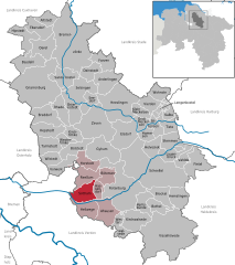
Location of Sottrum within Rotenburg (Wümme) district
  |
||
| Coordinates: 53°7′N 9°13′E / 53.117°N 9.217°ECoordinates: 53°7′N 9°13′E / 53.117°N 9.217°E | ||
| Country | Germany | |
| State | Lower Saxony | |
| District | Rotenburg (Wümme) | |
| Municipal assoc. | Sottrum | |
| Government | ||
| • Mayor | Hans-Jürgen Krahn (CDU) | |
| Area | ||
| • Total | 28.58 km2 (11.03 sq mi) | |
| Elevation | 20 m (70 ft) | |
| Population (2015-12-31) | ||
| • Total | 6,353 | |
| • Density | 220/km2 (580/sq mi) | |
| Time zone | CET/CEST (UTC+1/+2) | |
| Postal codes | 27367 | |
| Dialling codes | 04264 | |
| Vehicle registration | ROW | |
| Website | www.sottrum.de | |

Sottrum is a municipality in the district of Rotenburg, in Lower Saxony, Germany. It is situated approximately 11 km west of Rotenburg, and 30 km east of Bremen.
Sottrum belonged to the Prince-Bishopric of Verden, established in 1180. In 1648 the Prince-Bishopric was transformed into the Principality of Verden, which was first ruled in personal union by the Swedish Crown - interrupted by a Danish occupation (1712–1715) - and from 1715 on by the Hanoverian Crown. The Kingdom of Hanover incorporated the Principality in a real union and the Princely territory, including Sottrum, became part of the new Stade Region, established in 1823.
Sottrum is also the seat of the Samtgemeinde ("collective municipality") Sottrum.
...
Wikipedia