Souanké Airport
| Souanké Airport | |||||||||||
|---|---|---|---|---|---|---|---|---|---|---|---|
| Summary | |||||||||||
| Serves | Souanké, Republic of the Congo | ||||||||||
| Elevation AMSL | 1,722 ft / 525 m | ||||||||||
| Coordinates | 1°59′50″N 14°10′30″E / 1.99722°N 14.17500°ECoordinates: 1°59′50″N 14°10′30″E / 1.99722°N 14.17500°E | ||||||||||
| Map | |||||||||||
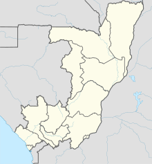
| Location of airport in the Republic of the Congo | |||||||||||
| Runways | |||||||||||
|
|||||||||||
|
Source: GCM Google Maps
|
|||||||||||
Souanké Airport (IATA: SOE, ICAO: FCOS) is an airport serving the town of Souanké, Republic of the Congo. The runway is 8 kilometres (5.0 mi) southeast of the town.
...
Wikipedia

