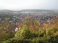
Sternenfels
| Sternenfels | ||
|---|---|---|

Sternenfels perspective from the Castle hill
|
||
|
||
| Coordinates: 49°3′1″N 8°51′02″E / 49.05028°N 8.85056°ECoordinates: 49°3′1″N 8°51′02″E / 49.05028°N 8.85056°E | ||
| Country | Germany | |
| State | Baden-Württemberg | |
| Admin. region | Karlsruhe | |
| District | Enzkreis | |
| Government | ||
| • Mayor | Sigrid Hornauer | |
| Area | ||
| • Total | 17.32 km2 (6.69 sq mi) | |
| Elevation | 397 m (1,302 ft) | |
| Population (2015-12-31) | ||
| • Total | 2,724 | |
| • Density | 160/km2 (410/sq mi) | |
| Time zone | CET/CEST (UTC+1/+2) | |
| Postal codes | 75447 | |
| Dialling codes | 07045 | |
| Vehicle registration | PF | |
| Website | www.sternenfels.de | |
Sternenfels, consisting of the villages of Diefenbach and Sternenfels, is the most northern municipality in the Enz (district) in Baden-Württemberg in Germany. The town is located at the border of the Kraichgau and Stromberg regions. Sternenfels is considered a showcase village and was mentioned in several national and European studies and competitions. It is about 20 km from Pforzheim and close to the UNESCO world heritage site of Maulbronn.
Sternenfels (Translation: star rock—a meaning which inspired the town coat of arms) has a peculiar location and citizens. The town has a very active community with more than 25 different associations; from different choruses, brass bands, a roaming pigeon club, a German Turkish council, a tourist board, various sport associations, political parties, winemaker and farmer associations. As well the town website has been awarded for it is a very active web community. The village has received several prizes in national competitions for renovation projects, beauty and sustainability.
Sternenfels has been the subject of several studies, dealing with regional and rural planning and sustainable development, as well as teleworking and rural industrial development
Sternenfels has been used as a Baden-Württemberg showcase village at EXPO 2000 and various other congresses and conferences. The expo participation is manifested in a monument on the main road.
Sternenfels is located on an exposed western spur of the east-west running Stromberg hills. The watershed between Rhine and Neckar rivers as well as the border between Kraichgau and Stromberg passes near Sternenfels. The Village of Diefenbach is the site of the Metter spring which runs via the Enz River to the Neckar, while the Kraich spring in Sternenfels ends in the Rhine river. Sternenfels is at the crossroads of four different counties - (Karlsruhe, Heilbronn, Ludwigsburg und Enzkreis). It is the starting or end point for several hiking or walking trails as well as part of Württemberg Wine route from Weikersheim to Metzingen. The former Roman road between Stettfeld and Bad Cannstatt probably crossed Sternenfels. The municipality became a local tourist destination with several inns and (former) breweries located around the town center.
...
Wikipedia


