Stony Cove Pike
| Stony Cove Pike | |
|---|---|

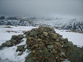
Cairn on Stony Cove Pike
|
|
| Highest point | |
| Elevation | 763 m (2,503 ft) |
| Prominence | 171 m (561 ft) |
| Parent peak | High Street |
| Listing | Marilyn, Hewitt, Wainwright, Nuttall |
| Coordinates | 54°28′55″N 2°54′05″W / 54.48198°N 2.90133°WCoordinates: 54°28′55″N 2°54′05″W / 54.48198°N 2.90133°W |
| Geography | |
| Location | Cumbria, England |
| Parent range | Lake District, Far Eastern Fells |
| OS grid | NY417100 |
| Topo map | OS Explorer OL5, Explorer OL7 |
Stony Cove Pike (alternatively known as Caudale Moor /kʊərdeɪl mʊər/ or John Bell's Banner) is a fell in the Far Eastern part of the English Lake District. It stands on the other side of the Kirkstone Pass from Red Screes, and is on the end of a ridge coming down from High Street. It is separated from its neighbours by the deep col of Threshthwaite Mouth, so is a Marilyn (a hill with topographic prominence of at least 150m) – the sixteenth highest in the Lake District.
There is considerable variation over use of the alternative names for the fell. The Ordnance Survey maps name the main summit as 'Stony Cove Pike', the second top to the west as 'Caudale Moor' and 'John Bell's Banner' is reserved for the south west ridge descending to St Raven's Edge. Alfred Wainwright in his Pictorial Guide to the Lakeland Fells uses Caudale Moor for the fell as a whole, John Bell's Banner as an alternative to this and Stony Cove Pike as a name for the (main) summit. Bill Birkett prefers the Ordnance Survey scheme, but with John Bell's Banner as a second name for the subsidiary top.
The fell is wide and sprawling, with six ridges leaving the summit area. The main summit sprouts four to the points of the compass. Eastward is the rocky descent to Threshwaite Mouth, followed by an equally steep climb to Thornthwaite Crag. Northward is the grassy ridge to Hartsop Dodd and westward the plateau narrows slightly toward the second top of Caudale Moor/ John Bell's Banner (2477 ft). To the south of the main top a short spur juts out into the head of the Trout Beck valley, before falling steeps over Doup Crag.
...
Wikipedia

