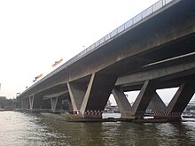
Taksin Bridge
| Taksin Bridge | |
|---|---|
 |
|
| Coordinates | 13°43′08″N 100°30′45″E / 13.718791°N 100.512543°ECoordinates: 13°43′08″N 100°30′45″E / 13.718791°N 100.512543°E |
| Carries | 6 lanes of roadway, Bangkok Skytrain, pedestrians |
| Crosses | Chao Phraya river |
| Locale | Bangkok, Thailand |
| Official name | King Taksin Bridge |
| Characteristics | |
| Total length | 1,791 m |
| Longest span | 92 m |
| Clearance below | 12 m |
| History | |
| Construction end | 1 February 1979 |
| Opened | 6 May 1982 |
The Taksin Bridge (Thai: สะพานสมเด็จพระเจ้าตากสิน) is a bridge crossing the Chao Phraya river in Bangkok, Thailand. The bridge was designed with a large gap between opposing traffic directions to accommodate a canceled mass transit system. The disused foundations were eventually adapted for the BTS Skytrain, with train services across the bridge beginning on 15 May 2009. 31 October 2011
The entry ramp on the east side of the river contains the Saphan Taksin Skytrain station as well as a pier for the Chao Phraya Express Boat.
...
Wikipedia
