Tempe Butte
| Tempe Butte | |
|---|---|
|
"A" Mountain O'odham: ʼOidbaḍ Doʼag |
|

Tempe Butte, or A Mountain, is a popular place to hike as it provides a view of ASU's Tempe campus and downtown Tempe.
|
|
| Highest point | |
| Elevation | 1,398 ft (426 m) NAVD 88 |
| Prominence | 330 ft (100 m) |
| Coordinates | 33°25′42″N 111°56′09″W / 33.428234536°N 111.935780928°WCoordinates: 33°25′42″N 111°56′09″W / 33.428234536°N 111.935780928°W |
| Geography | |
| Location |
Tempe Maricopa County, Arizona, U.S. |
| Topo map | USGS Tempe |
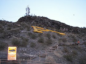
Tempe Butte (O'odham: ʼOidbaḍ Doʼag) is the official name of an andesite butte of volcanic origin, located partially on Arizona State University's Tempe campus in Tempe, Arizona. It is often referred to by locals as A Mountain, after the 60-foot-tall (18 m) gold-painted letter 'A' near the top. Another name for the area, used by the City of Tempe, is Hayden Butte.
The highest point of Tempe Butte stands at 1,398 feet (426 m) in elevation, while its base is at approximately 1,150 feet (350 m) in elevation.
Tempe Butte is most often seen as the backdrop to games held in Sun Devil Stadium, including until recently the Tostitos Fiesta Bowl, as well as Super Bowl XXX.
Originally, Tempe Butte was part of a series of horizontal layers, but the strata has been tilted associated with the formation of South Mountain, and millennia of erosion has created the distinctive hogback of resistant andesite, over sedimentary deposits and rhyolite beds.
Despite intensive development, the butte and its immediate surroundings continue to support a variety of native vegetation, including saguaro, Buckhorn Cholla, barrel cactus, creosote bush, palo verde, and mesquite. Native wildlife include jackrabbits, and small desert-adapted species such as pack rats.
...
Wikipedia

