The Bluff (Ypres)
| The Bluff | |||||||||
|---|---|---|---|---|---|---|---|---|---|
| Part of the First World War | |||||||||
 The Bluff, St Eloi |
|||||||||
|
|||||||||
| Belligerents | |||||||||
|
|
|
||||||||
| Commanders and leaders | |||||||||
| Erich von Falkenhayn | Douglas Haig | ||||||||
| Strength | |||||||||
| 2 Regiments | 2 Brigades | ||||||||
| Casualties and losses | |||||||||
| 14–18 February: 329 2 March: 908 |
14–17 February: 1,294 2–4 March:1,622 |
||||||||
|
|
|||||||||
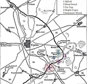
The Actions of the Bluff were local operations carried out in Flanders during the First World War by the German 4th Army and the British Second Army in 1916. The Bluff is a mound near St Eloi, south-east of Ypres in Belgium, created from a spoil heap during the digging of the Ypres–Comines Canal before the war. From 14–15 February and on 2 March 1916, the Germans and the British fought for control of the Bluff, the Germans capturing the mound and defeating counter-attacks only for the British to recapture it and a stretch of the former German front line, after pausing to prepare a set-piece attack.
The fighting at the Bluff was one of nine sudden attacks for local gains made by the Germans or the British between the appointment of Sir Douglas Haig as commander in chief of the BEF and the beginning of the Battle of the Somme. The BEF was at a tactical disadvantage against the German army, on low boggy ground, easily observed from German positions. A retirement to more defensible ground was impossible but rather than conserving manpower and resouces with a tacit truce, the British kept an active front and five of the German local attacks in the period were retaliation for three British set-piece attacks.
The Germans had better weapons and could move troops and equipment along the Western Front easier than the Franco-British. The German army still had many pre-war trained officers NCOs and soldiers. The British wartime volunteers gained experience in minor tactics but success usually came from firepower; in the underground war, the BEF tunnellers overtook the Germans in technological ability and ambition. Capturing a portion of the front line was possible but holding it depended on the opponent. When the Bluff was captured, the British retook it; Mount Sorrel and Tor Top were retaken by the Canadians and British gains at St Eloi and Vimy Ridge were lost to German attacks. Had the British occupied the front less densely, more training could have taken place and the wisdom of each policy was debated at the time and since.
Ypres is overlooked by Kemmel Hill in the south-west and from the east by low hills running south-west to north-east with Wytschaete (Wijtschate), Hill 60 to the east of Verbrandenmolen, Hooge, Polygon Wood and Passchendaele (Passendale). The high point of the ridge is at Wytschaete, 7,000 yd (6,400 m) from Ypres, while at Hollebeke the ridge is 4,000 yd (3,700 m) distant and recedes to 7,000 yd (6,400 m) at Polygon Wood. Wytschaete is about 150 ft (46 m) above the plain; on the Ypres–Menin road at Hooge, the elevation is about 100 ft (30 m) and 70 ft (21 m) at Passchendaele. The rises are slight apart from the vicinity of Zonnebeke, which has a 1:33 gradient. From Hooge and to the east, the slope is 1:60 and near Hollebeke, it is 1:75; the heights are subtle but have the character of a saucer lip around Ypres. The main ridge has spurs sloping east and one is particularly noticeable at Wytschaete, which runs 2 mi (3.2 km) south-east to Messines (Mesen) with a gentle slope to the east and a 1:10 decline to the west. Further south is the muddy valley of the Douve river, Ploegsteert Wood (Plugstreet to the British) and Hill 63. West of Messines Ridge is the parallel Wulverghem (Spanbroekmolen) Spur; the Oosttaverne Spur, also parallel, is to the east. The general aspect south of Ypres is of low ridges and dips, gradually flattening to the north into a featureless plain.
...
Wikipedia

