Toshima, Tokyo
|
Toshima 豊島区 |
||
|---|---|---|
| Special ward | ||
| Toshima City | ||

Ikebukuro at night in Toshima
|
||
|
||
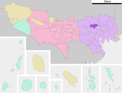
 Location of Toshima in Tokyo |
||
| Location in Japan | ||
| Coordinates: 35°43′56.85″N 139°42′55.46″E / 35.7324583°N 139.7154056°ECoordinates: 35°43′56.85″N 139°42′55.46″E / 35.7324583°N 139.7154056°E | ||
| Country | Japan | |
| Region | Kantō | |
| Prefecture | Tokyo | |
| Government | ||
| • Mayor | Yukio Takano | |
| Area | ||
| • Total | 13.01 km2 (5.02 sq mi) | |
| Population (May 1, 2015) | ||
| • Total | 298,250 | |
| • Density | 22,920/km2 (59,400/sq mi) | |
| Symbols | ||
| • Tree | Prunus X yedoenis | |
| • Flower | Azalea | |
| Time zone | Japan Standard Time (UTC+9) | |
| City hall address | 1-18-1 Higashi Ikebukuro 170-8422 |
|
| Website | www |
|
Toshima (豊島区 Toshima-ku?) is a special ward in Tokyo, Japan. It is one of the eight central wards of the Tokyo Metropolitan area, including Chiyoda, Minato, Shibuya, Chuo, Shinjuku, Taito, and Bunkyo surrounding the Imperial Palace. Located in the northern area of Tokyo, Toshima is bordered by the wards of Nerima, Itabashi, and Kita wards, in the north, and Nakano, Shinjuku and Bunkyo in the south.
The ward was founded on March 15, 1947 and reached a peak resident population of 370,000 in 1965. The population has continued to decline and as of May 1, 2015, the ward had an estimated population of 298,250 with a population density of 22,920 persons per km². During the day the population swells with commuters, resulting in a daytime population of around 378,475.
The total land area of Toshima is 13.01 km², sitting on a moderate plateau with a difference of 28 m between the ward's highest and lowest points. Approximately 47% of Toshima's land is residential, and 20% is commercial and public areas.
Although Toshima is a ward, it is referred to as a city. The ward offices are located in Ikebukuro, which is also the commercial and entertainment center of Toshima.
...
Wikipedia


