Usedom
| Nickname: Sunny Island | |
|---|---|

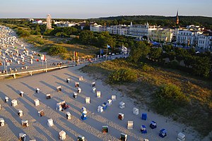
Beach, dune, and promenade in Ahlbeck – a distinctive seaside resort, typical for the Island of Usedom
|
|
| Geography | |
| Location | Baltic Sea |
| Area | 445 km2 (172 sq mi) |
| Length | 66.4 km (41.26 mi) |
| Width | 23.9 km (14.85 mi) |
| Coastline | 110 km (68 mi) |
| Highest elevation | 69 m (226 ft) |
| Highest point | Golm |
| Administration | |
|
Germany
|
|
| State | Mecklenburg-Vorpommern |
| District | Vorpommern-Greifswald |
| Largest settlement | Greifswald |
|
Poland
|
|
| Voivodeship | West Pomeranian Voivodeship |
| Largest settlement | Świnoujście |
| Demographics | |
| Demonym | Usedomers |
| Population | 76,500 (2012) |
| Pop. density | 172 /km2 (445 /sq mi) |
| Ethnic groups | Germans, Poles |
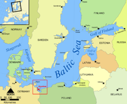
Usedom (German: Usedom [ˈuːzədɔm], Polish: Uznam [ˈuznam]) is a Baltic Sea island in Pomerania, since 1945 split between Germany and Poland. It is the second biggest Pomeranian island after Rügen and before neighbouring Wolin.
It is situated north of the Stettin Lagoon (Polish: Zalew Szczeciński; German: Stettiner Haff) estuary of the River Oder. About 80% of the island belongs to the German district of Vorpommern-Greifswald in the state of Mecklenburg-Vorpommern. The eastern part and the largest city on the island, Świnoujście (German: Swinemünde), are part of the Polish West Pomeranian Voivodeship. The island's total area is 445 square kilometres (172 square miles) (the German part 373 square kilometres (144 square miles); the Polish part 72 square kilometres (28 square miles)). Its population is 76,500 (the German part 31,500; the Polish part 45,000).
With an annual average of 1906 sunshine hours, Usedom is the sunniest region of both Germany and Poland, and it is also the sunniest island in the Baltic Sea. Hence its nickname Sunny Island (German: Sonneninsel, Polish: Wyspa Słońca).
...
Wikipedia

