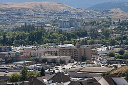
Vernon, British Columbia
| Vernon | |
|---|---|
| City | |
| The Corporation of the City of Vernon | |

Downtown Vernon
|
|
| Location of Vernon in British Columbia | |
| Coordinates: 50°16′00″N 119°16′18″W / 50.26667°N 119.27167°W | |
| Country |
|
| Province |
|
| Regional District | North Okanagan |
| Incorporated | December 30, 1892 |
| Government | |
| • Mayor | Akbal Mund |
| • Governing Body | Vernon City Council |
| • MP | Mel Arnold |
| • MLA | Eric Foster |
| Area | |
| • City | 95.76 km2 (36.97 sq mi) |
| • Metro | 1,040.82 km2 (401.86 sq mi) |
| Elevation | 380 m (1,250 ft) |
| Population (2011) | |
| • City | 40,000 |
| • Density | 398.4/km2 (1,032/sq mi) |
| • Urban | 44,600 |
| • Metro | 58,584 |
| • Metro density | 56.3/km2 (146/sq mi) |
| Time zone | Pacific Time Zone (UTC-8) |
| • Summer (DST) | Pacific Daylight Time (UTC-7) |
| Postal code span | V1B, V1H, V1T |
| Area code(s) | 250 / 778 / 236 |
| Highways |
|
| Website | City of Vernon |
Vernon is a city in the Okanagan region of the Southern Interior of British Columbia, Canada. It is 440 km (270 mi) northeast of Vancouver. Named after Forbes George Vernon, a former MLA of British Columbia who helped found the famed Coldstream Ranch in nearby Coldstream, the City of Vernon was incorporated on December 30, 1892. The City of Vernon has a population of 40,000 (2013), while its metropolitan region, Greater Vernon, has a population of 58,584 as of the Canada 2011 Census. With this population, Vernon is the largest city in the North Okanagan Regional District. A resident of Vernon is called a "Vernonite".
In 2005, on an episode of The Early Show, Vernon was ranked as one of the top six most desirable communities to retire to in North America by Consumer Reports.
The site of the city was first discovered by the Okanagan people, a tribe of the Interior Salish people, who initially named the community Nintle Moos Chin, meaning "jumping over place where the creek narrows", which refers to a section of the Swan Lake that passes through Downtown Vernon, the community's central business district. Some of these were part of the Okanagan Indian Band, a First Nations government part of the Okanagan Nation Alliance. This was followed by Priest's Valley, which serves as an Indian reserve, and its present name, in honour of Forbes George Vernon, a pioneer member part of the Legislative Assembly of British Columbia for Yale. The Okanagan people settled around the city's two lakes, Okanagan Lake and Swan Lake, obtaining seasonal sources of food. In that same decade, a section of a road near Fort Kamloops became its first road. Pleasant Valley Road, situated north of that street, was also historically developed.
...
Wikipedia

