Weißseespitze
| Weißseespitze | |
|---|---|

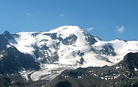
Weißseespitze from the north.
|
|
| Highest point | |
| Elevation | 3,526 m (11,568 ft) |
| Prominence | 341 m (1,119 ft) |
| Isolation | 5.07 kilometres (3.15 mi) |
| Parent peak | Hochvernagtspitze |
| Coordinates | 46°50′48″N 10°43′02″E / 46.84667°N 10.71722°ECoordinates: 46°50′48″N 10°43′02″E / 46.84667°N 10.71722°E |
| Geography | |
| Location | Tyrol, Austria / South Tyrol, Italy |
| Parent range | Ötztal Alps |
| Climbing | |
| First ascent | 1870 by Franz Senn, V. v. Mayrl. J. Wanderer and the guide I. Schöpf |
| Easiest route | von Norden und über den Westgrat |
The Weißseespitze is a mountain in the Weisskamm group of the Ötztal Alps. It has an elevation of 3,526 m above sea level.
...
Wikipedia

