Worchester
| City of Worcester | ||
|---|---|---|
| Cathedral City and non-metropolitan district | ||

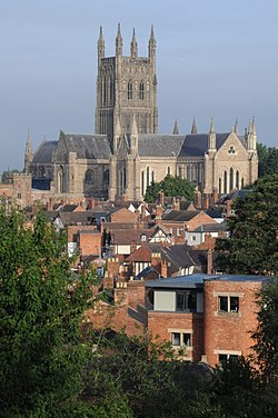
Worcester Cathedral from Fort Royal Hill
|
||
|
||
 City of Worcester shown within Worcestershire |
||
| Coordinates: 52°11′28″N 2°13′20″W / 52.19123°N 2.22231°WCoordinates: 52°11′28″N 2°13′20″W / 52.19123°N 2.22231°W | ||
| Sovereign state | United Kingdom | |
| Constituent country | England | |
| Region | West Midlands | |
| Non-metropolitan county | Worcestershire | |
| Status | Non-metropolitan district, City | |
| Admin HQ | Worcester | |
| Government | ||
| • Type | Non-metropolitan district council | |
| • Borough council | Worcester City Council (Labour (council NOC)) | |
| • MPs | Robin Walker (Conservative) | |
| Area | ||
| • Total | 12.85 sq mi (33.28 km2) | |
| Area rank | 305th (of 326) | |
| Population (mid-2015) | ||
| • Total | 101,328 | |
| • Rank | 232nd (of 326) | |
| • Density | 7,900/sq mi (3,000/km2) | |
| Time zone | GMT (UTC0) | |
| • Summer (DST) | BST (UTC+1) | |
| Postcodes | WR1-5 | |
| Area code(s) | 01905 | |
| ONS code | 47UE (ONS) E07000237 (GSS) |
|
| OS grid reference | SO849548 | |
| Website | www |
|
Worcester (/ˈwʊstər/ WUUS-tər) is a city in Worcestershire, England, 31 miles (50 km) southwest of Birmingham and 27 miles (43 km) north of Gloucester. The population is approximately 100,000. The River Severn flanks the western side of the city centre, which is overlooked by the 12th-century Worcester Cathedral.
The Battle of Worcester was the final battle of the English Civil War, where Oliver Cromwell's New Model Army defeated King Charles I's Cavaliers. Worcester is known as the home of Royal Worcester Porcelain, composer Edward Elgar,Lea & Perrins, makers of traditional Worcestershire sauce, and the University of Worcester.
The trade route past Worcester which later formed part of the Roman Ryknild Street dates to Neolithic times. The position commanded a ford over the River Severn (the river was tidal past Worcester prior to public works projects in the 1840s) and was fortified by the Britons around 400 BC. It would have been on the northern border of the Dobunni and probably subject to the larger communities of the Malvern hillforts. The Roman settlement at the site passes unmentioned by Ptolemy's Geography, the Antonine Itinerary and the Register of Dignitaries but would have grown up on the road opened between Glevum (Gloucester) and Viroconium (Wroxeter) in the AD 40s and 50s. It may have been the "Vertis" mentioned in the 7th-century Ravenna Cosmography. Using charcoal from the Forest of Dean, the Romans operated pottery kilns and ironworks at the site and may have built a small fort.
...
Wikipedia

