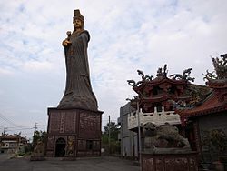
Xinwu District, Taoyuan
|
Xinwu 新屋區 |
|
|---|---|
| District | |
| Xinwu District | |
 |
|
 |
|
| Coordinates: 24°58′41″N 121°04′03″E / 24.97806°N 121.06750°E | |
| Country | Taiwan |
| Region | Northern Taiwan |
| Government | |
| • Mayor | Xu Tongzhi |
| Area | |
| • Total | 85.0166 km2 (32.8251 sq mi) |
| Population (January 2016) | |
| • Total | 48,469 |
| • Density | 570/km2 (1,500/sq mi) |
| Website | www.xinwu.tycg.gov.tw (Chinese) |
| Xinwu District, Taoyuan | |||||||||

The Duck
|
|||||||||
| Chinese | |||||||||
|---|---|---|---|---|---|---|---|---|---|
| Postal | Sinwu | ||||||||
|
|||||||||
| Transcriptions | |
|---|---|
| Standard Mandarin | |
| Hanyu Pinyin | Xīnwū |
| Wade–Giles | Hsin-wu |
Coordinates: 24°58′N 121°06′E / 24.967°N 121.100°E
Xinwu or Sinwu District is a rural, coastal district in southeast Taoyuan, Taiwan.
Xinwu District accounts for almost 7% of Taoyuan's total land area and is the 6th largest township in Taoyuan County. Local industries include agriculture, fisheries, and livestock. 90% of Xinwu residents are Hakka.
Many rivers flow through the township, including the Shezih River, Sinwu River, Foshing River, Fusing River, and Houhu River.
Xinwu Village, Xinsheng Village, Houhu Village, Qinghua Village, Shilei Village, Tungming Village, Shezi Village, Puding Village, Jiudou Village, Touzhou Village, Dapo Village, Wangjian Village, Houzhuang Village, Kejian Village, Shenzun Village, Kanglang Village, Bengang Village, Yongan Village, Yongxing Village, Xiapu Village, Shipai Village, Xiatian Village, Chilan Village.
Xinwu has 11 elementary schools, 3 junior high schools, and one high school. It also has one township nursery, three kindergartens, other private kindergartens, and a township library.
Xinwu is served by Provincial Highway No. 66.
...
Wikipedia
