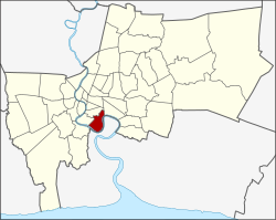
Yan Nawa
|
Yan Nawa ยานนาวา |
|
|---|---|
| Khet | |

|
|
 Khet location in Bangkok |
|
| Coordinates: 13°41′49″N 100°32′35″E / 13.69694°N 100.54306°ECoordinates: 13°41′49″N 100°32′35″E / 13.69694°N 100.54306°E | |
| Country | Thailand |
| Province | Bangkok |
| Seat | Chong Nonsi |
| Khwaeng | 2 |
| Area | |
| • Total | 16.662 km2 (6.433 sq mi) |
| Population (2015) | |
| • Total | 80,211 |
| • Density | 4,814.00/km2 (12,468.2/sq mi) |
| Time zone | ICT (UTC+7) |
| Postal code | 10120 |
| Geocode | 1012 |
Yan Nawa or Yannawa (Thai: ยานนาวา; IPA: [jāːn nāːwāː]) is one of the 50 districts (khet) of Bangkok, Thailand. The district is bounded by (clockwise from west to northeast) Rat Burana (across Chao Phraya River), Bang Kho Laem, Sathon and Khlong Toei Districts of Bangkok while its remaining neighbor from east to south is Amphoe Phra Pradaeng of Samut Prakan Province.
Yan Nawa, in the past, was called Ban Thawai (Tavoy village, บ้านทะวาย) or Ban Khok Khwai (water buffalo pen village, บ้านคอกควาย) due to a large concentration of Tavoy people who often brought water buffaloes to market for trade. It became Amphoe Ban Thawai during King Chulalongkorn's rule, and was part of Phra Pradaeng Province. When that province was abolished in 1932, its northern parts were added to Phra Nakhon (Bangkok) Province. Ban Tavoy was then renamed to Amphoe Yan Nawa in agreement with the earlier rename of Wat Ban Thawai to Wat Yan Nawa. It became a khet in 1972 and the present-day kwaengs were devised in 1975. On 9 November 1989 parts of Yan Nawa were split off to form two new districts, Sathon and Bang Kho Laem. Wat Yan Nawa, the temple the district name inherits, is now in Sathon District.
...
Wikipedia
