Ynysybwl
Ynysybwl
|
|
|---|---|
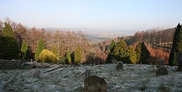
 Llanwynno Forest in winter, as seen from St Gwynno's Church |
|
| Ynysybwl shown within Rhondda Cynon Taf | |
| Population | 4,664 (2011) |
| OS grid reference | ST054949 |
| Principal area | |
| Ceremonial county | |
| Country | Wales |
| Sovereign state | United Kingdom |
| Post town | Pontypridd |
| Postcode district | CF37 |
| Dialling code | 01443 |
| Police | South Wales |
| Fire | South Wales |
| Ambulance | Welsh |
| EU Parliament | Wales |
| UK Parliament | |
| Welsh Assembly | |
Ynysybwl (Welsh: Ynys-y-bŵl [ənɪsəˈbʊl]) is a village in Cwm Clydach in Wales. It is situated in the county borough of Rhondda Cynon Taf, roughly 15 miles (24 km) north-north-west of Cardiff, 5 miles (8 km) north of Pontypridd and 16 miles (26 km) south of Merthyr Tydfil, and forms part of the community of Ynysybwl and Coed-y-cwm.
Cwm Clydach is flanked by the Rhondda and Cynon Valleys. The market town of Pontypridd lies to the south at the meeting point of the three valleys; and to the north lies the large Llanwynno forestry. Before the local government reforms of 1996 Ynysybwl was in the Cynon Valley district of Morgannwg Ganol, and the area is historically a part of Glamorgan (Morgannwg).
There is uncertainty over the meaning of the name of the village.
Ynys means 'island' or 'river meadow' in Welsh and probably refers to such a meadow on the banks of the Clydach stream. The 'bŵl' element is more difficult. Some theories include 'bowl/ball' [see 'bŵl' GPC] possibly a reference to the shape of the river-meadow or to a handball game played locally).
Locally, the village is often referred to as just "Bwl" or "The Bwl".
Ynysybwl is located in the centre of the Llanwynno parish, at the point where the stream known as Y Ffrwd flows into the Nant Clydach. Then a collection of small local farms and meadows in a quiet and completely rural valley, at the 1841 census around 200 people lived in the village and surrounding farms.
The rich seams of coal in the Mynachdy level that lie beneath the surface had thus far only been tapped to the amount required to supply these local farms. David Davies began test bores in the early 1880s at Graigddu ("Black Rock"), which proved positive, and the resultant sinking of Lady Windsor Colliery by the Ocean Coal Company on 16 June 1884 gave birth to new coal town.
...
Wikipedia

