Zhumulangma
| Mount Everest | |
|---|---|
|
सगरमाथा (Sagarmāthā) ཇོ་མོ་གླང་མ (Chomolungma) 珠穆朗玛峰 (Zhūmùlǎngmǎ Fēng) |
|

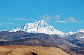
Everest's north face from the Tibetan plateau
|
|
| Highest point | |
| Elevation | 8,848 metres (29,029 ft) Ranked 1st |
| Prominence | 8,848 metres (29,029 ft) Ranked 1st (Notice special definition for Everest) |
| Listing |
Seven Summits Eight-thousander Country high point Ultra |
| Coordinates | 27°59′17″N 86°55′31″E / 27.98806°N 86.92528°ECoordinates: 27°59′17″N 86°55′31″E / 27.98806°N 86.92528°E |
| Geography | |
| Location |
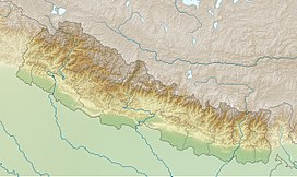
Solukhumbu District, Sagarmatha Zone, Nepal; Tingri County, Xigazê, Tibet Autonomous Region, China |
| Parent range | Mahalangur Himal, Himalayas |
| Climbing | |
| First ascent | 29 May 1953 Edmund Hillary and Tenzing Norgay |
| Normal route | southeast ridge (Nepal) |
| Location | Altitude (km) | |
|---|---|---|
| Base camp 5400 m / 17700 ft. | 5.4 |
|
| Camp 1 6100 m / 20000 ft. | 6.1 |
|
| Camp 2 6400 m / 21000 ft. | 6.4 |
|
| Camp 3 6800m / 22300 ft. | 6.8 |
|
| Camp 4 8000 m / 26000 ft. | 8 |
|
| Summit 8850 m / 29035 ft. | 8.8 |
|
|
|
Mount Everest, also known in Nepali as Sagarmāthā and in Tibetan as Chomolungma, is Earth's highest mountain. Its peak is 8,848 metres (29,029 ft) above sea level. Mount Everest is in the Mahalangur Range. The international border between China (Tibet Autonomous Region) and Nepal runs across Everest's summit point. Nearby peaks include Lhotse, 8,516 m (27,940 ft); Nuptse, 7,855 m (25,771 ft), and Changtse, 7,580 m (24,870 ft) among others. Another nearby peak is Khumbutse, and many of the highest mountains in the world are near Mount Everest.
In 1715, China surveyed the mountain while mapping Chinese territory and depicted it as Mount Qomolangma no later than 1719. In 1856, the Great Trigonometrical Survey of India established the first published height of the mountain, then known as Peak XV, at 8,840 m (29,002 ft). The current official height of 8,848 m (29,029 ft) as recognised by China and Nepal was established by a 1955 Indian survey and subsequently confirmed by a Chinese survey in 1975. In 2005, China remeasured the height of the mountain and got a result of 8844.43 m.
An argument regarding the height between China and Nepal lasted five years from 2005 to 2010. China argued it should be measured by its rock height of 8,844 m, but Nepal said it should be measured by its snow height of 8,848 m. In 2010, an agreement was finally reached by both sides that the height of Everest is 8,848 m, and Nepal recognises China's claim that the rock height of Everest is 8,844 m.
In 1865, Everest was given its official English name by the Royal Geographical Society, upon a recommendation by Andrew Waugh, the British Surveyor General of India. As there appeared to be several different local names, Waugh chose to name the mountain after his predecessor in the post, Sir George Everest, despite George Everest's objections.
...
Wikipedia


