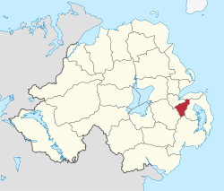
Castlereagh (borough)
| Castlereagh Borough | |
|---|---|
 |
|
| Area | 85 km2 (33 sq mi) Ranked 24th of 26 |
| District HQ | Upper Galwally, Newtownbreda |
| Catholic | 22.2% |
| Protestant | 67.9% |
| Country | Northern Ireland |
| Sovereign state | United Kingdom |
| EU Parliament | Northern Ireland |
| Councillors |
|
| Website | www |
Castlereagh (/ˈkɑːsəlreɪ/ KAH-səl-ray, (from Irish: An Caisleán Riabhach, meaning "the grey castle") was a local government district with the status of borough in Northern Ireland. It merged with Lisburn City Council in May 2015 under local government reorganisation in Northern Ireland to become Lisburn and Castlereagh City Council, with a small amount being transferred to Belfast City Council.
It was a mainly urban borough consisting mostly of suburbs of Belfast in the Castlereagh Hills (to the south-east of the city) with a small rural area in the south of the borough. Unusually, it had no natural borough centre. The main centres of population are Carryduff, 6 miles (9.6 km) south of Belfast city centre and Dundonald, 5 miles (8 km) east of it.
Castlereagh was named after the barony of Castlereagh, which in turn was named after the townland of same name.
The district was one of twenty-six created on 1 October 1973. It was formed by the amalgamation of the following areas of County Down: most of Castlereagh Rural District, the Carryduff and Newtownbreda areas of Hillsborough Rural District and the Moneyreagh area of North Down Rural District.
...
Wikipedia
