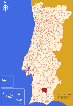
Castro Verde Municipality
| Castro Verde | |||
|---|---|---|---|
| Municipality | |||

Castro Verde as seen from the Monument to the Battle of Ourique in São Pedro de Cabeças
|
|||
|
|||
 |
|||
| Coordinates: 37°42′15″N 8°1′23″W / 37.70417°N 8.02306°WCoordinates: 37°42′15″N 8°1′23″W / 37.70417°N 8.02306°W | |||
| Country |
|
||
| Region | Alentejo | ||
| Subregion | Baixo Alentejo | ||
| Intermunic. comm. | Baixo Alentejo | ||
| District | Beja | ||
| Parishes | 4 | ||
| Government | |||
| • President | Francisco José Caldeira Duarte (CDU) | ||
| Area | |||
| • Total | 569.44 km2 (219.86 sq mi) | ||
| Elevation | 180 m (590 ft) | ||
| Population (2011) | |||
| • Total | 7,276 | ||
| • Density | 13/km2 (33/sq mi) | ||
| Time zone | WET/WEST (UTC+0/+1) | ||
| Postal code | 7780 | ||
| Area code | 286 | ||
| Patron | São Pedro | ||
| Website | http://www.cm-castroverde.pt | ||
Castro Verde (Portuguese pronunciation: [ˈkaʃtɾu ˈveɾd(ɨ)]) is a town and a municipality of the Alentejo region of Portugal (in the historic district of Beja). The population in 2011 was 7,276, in an area of 569.44 km2. Castro Verde is situated in the Baixo Alentejo subregion, within a territory known locally as the Campo Branco (English: White Plains). The municipality can be recognized by the local municipal markers along its borders, that appear within its borders to denote its reference as A Window on the Plains; municipal markers appear as stylized house profiles, with an exaggerated window that allows the visitor to see through into the panorama.
The pre-History of the Baixo Alentejo Subregion dates back to 200,000 B.C. when the territory was crossed by migratory Neanderthal peoples from the north of Europe in the Lower Paleolithic period. Until their extinction, around 28,000 B.C., Neanderthal man hunted and forged in present-day Portugal. Later, the area was home to several cultures due to the abundance of minerals and its commercial and strategic place along the Mediterranean. The earliest settlements began with Celtiberians, from the central Iberian Peninsula around the 6th Century B.C., and were followed by the Celts. From the 3rd Century, tribal clans were replaced by organized oppidum, a fortified organized city with a defined territory that included many castro villages constructed from large boulders or earthworks.
The first evidence of early cultures in the area of Castro Verde was the discovery of the 'Syllabary of Espança', which was found near the village of Neves-Corvo in the civil parish of Santa Bárbara de Padrões. This archaeological stone contains a Southwest Paleohispanic script, using Tartessian script and language, identified as being the most ancient paleohispanic script; related to the Phoenician alphabet, it is the closest European connection to the Phoenician culture. The Tartessian culture was the precursors of the Turdetani peoples of the Roman period. Growth of settlements during the classic period were likely associated with the strategic importance of the Iberian Pyrite zone. Castro Verde lies along a transport route linking the mines of Aljustrel (20 km to the north) with the port city of Mértola (40 km to the east) situated on tributaries of the Guadiana river. During the Roman occupation, the extensive mining and warehousing of minerals required protective fortifications and mineral warehouses: in the Castro Verde territory there are remains of more than 20 such small structures. Along with mining activities, the area became a vast area of grain production and cattle/sheep-grazing. The richness and abundance of these combined 'base economies' grew to such extent that Castro Verde became a regional centre of commerce and thus a crossroad of cultures within the Mediterranean area.
...
Wikipedia


