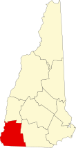
Cheshire County, New Hampshire
| Cheshire County, New Hampshire | ||
|---|---|---|

Cheshire County Courthouse in Keene
|
||
|
||
 Location in the U.S. state of New Hampshire |
||
 New Hampshire's location in the U.S. |
||
| Founded | 1769 | |
| Named for | Cheshire | |
| Seat | Keene | |
| Largest city | Keene | |
| Area | ||
| • Total | 729 sq mi (1,888 km2) | |
| • Land | 707 sq mi (1,831 km2) | |
| • Water | 22 sq mi (57 km2), 3.1% | |
| Population | ||
| • (2010) | 77,117 | |
| • Density | 109/sq mi (42/km²) | |
| Congressional district | 2nd | |
| Time zone | Eastern: UTC-5/-4 | |
| Website | co |
|
Cheshire County is a county located in the southwestern portion of the U.S. state of New Hampshire. As of the 2010 census, the population was 77,117. Its county seat is the city of Keene. Cheshire was one of the five original counties of New Hampshire, and is named for the county of Cheshire in England. It was organized in 1771 at Keene.
Cheshire County comprises the Keene, NH Micropolitan Statistical Area.
According to the U.S. Census Bureau, the county has a total area of 729 square miles (1,890 km2), of which 707 square miles (1,830 km2) is land and 22 square miles (57 km2) (3.1%) is water. The highest point in Cheshire county is Mount Monadnock, in the northwestern part of Jaffrey, at 3,165 feet (965 m).
As of the census of 2000, there were 73,825 people, 28,299 households, and 18,790 families residing in the county. The population density was 104 people per square mile (40/km²). There were 31,876 housing units at an average density of 45 per square mile (17/km²). The racial makeup of the county was 97.75% White, 0.37% Black or African American, 0.31% Native American, 0.47% Asian, 0.04% Pacific Islander, 0.18% from other races, and 0.89% from two or more races. 0.72% of the population were Hispanic or Latino of any race. 16.2% were of English, 13.1% French, 12.7% Irish, 9.3% American, 8.7% French Canadian, 6.7% Italian and 6.5% German ancestry according to Census 2000. 95.5% spoke English, 1.4% French and 1.2% Spanish as their first language.
...
Wikipedia

