Cotuit, Massachusetts
| Cotuit, Massachusetts | |
|---|---|
| Village | |
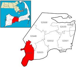
 Location of ZIP code 02635 Cotuit within the Town of Barnstable, county, and state |
|
| Coordinates: 41°37′00″N 70°26′13″W / 41.61667°N 70.43694°WCoordinates: 41°37′00″N 70°26′13″W / 41.61667°N 70.43694°W | |
| Country | United States |
| State | Massachusetts |
| County | Barnstable |
| Town | Barnstable, MA |
| Area | |
| • Total | 6.60 sq mi (17.10 km2) |
| • Land | 5.50 sq mi (14.25 km2) |
| • Water | 1.10 sq mi (2.85 km2) |
| Population (1995 estimate) | |
| • Total | 3,296 |
| • Density | 599.3/sq mi (231.38/km2) |
| Time zone | Eastern (EST) (UTC-5) |
| • Summer (DST) | EDT (UTC-4) |
Cotuit (/koh too it/) is one of the villages of the Town of Barnstable on Cape Cod in Barnstable County, Massachusetts, United States. Located on a peninsula on the south side of Barnstable about midway between Falmouth and Hyannis, Cotuit is bounded by the Santuit River to the west on the Mashpee town line, the villages of Marstons Mills to the north and Osterville to the east, and Nantucket Sound to the south. Cotuit is primarily residential with several small beaches including Ropes Beach, Riley's Beach, The Loop Beach and Oregon Beach.
Cotuit was part of a major land purchase negotiated by Myles Standish of the Plymouth Colony with Paupmunnuck, Wampanoag headman of the Cotachessett village allegedly located on or near the island known today as Oyster Harbors, or Grand Island. That transaction, which occurred on May 17, 1648, was made by Paupmunnuck and his brother, and "sold" about "twenty square miles of land in what is now the southwestern section of Barnstable."
The purchase price was two kettles, a bushel of Indian corn, and the agreement to fence off 30 acres (120,000 m2) of land comprising the Cotachessett village. However this was renegotiated shortly after the conclusion of the Standish agreement to drop the fence and corn and settled instead on a price of "one great brass kettle seven spans in wideness round about, and one broad hoe."
Cattle and the harvesting of salt marsh hay was the primary economic activity in colonial Cotuit. The Little River section of the village (near the present location of the Cotuit Oyster Company) was the site of some early shipyards.
...
Wikipedia
