Elk Mountains (Colorado)
| Elk Mountains | |
|---|---|

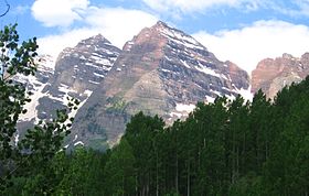
The Maroon Bells, Elk Mountains.
|
|
| Highest point | |
| Peak | Castle Peak |
| Elevation | 14,265 ft (4,348 m) |
| Coordinates | 39°00′35″N 106°51′14″W / 39.00972°N 106.85389°WCoordinates: 39°00′35″N 106°51′14″W / 39.00972°N 106.85389°W |
| Geography | |
| Country | United States |
| State | Colorado |
| County | Pitkin, Gunnison and Eagle |
| Parent range | Rocky Mountains |
| Borders on | Sawatch Range and West Elk Mountains |
The Elk Mountains are a high, rugged mountain range in the Rocky Mountains of west-central Colorado in the United States. The mountains sit on the western side of the Continental Divide, largely in southern Pitkin and northern Gunnison counties, in the area southwest of Aspen, south of the Roaring Fork River valley, and east of the Crystal River. The range sits west of the Sawatch Range and northeast of the West Elk Mountains. Much of the range is located within the White River National Forest and the Gunnison National Forest, as well as the Maroon Bells-Snowmass Wilderness and Raggeds Wilderness. The Elk Mountains rise nearly 9,000 ft. above the Roaring Fork Valley to the north.
The highest peaks in the range are its fourteeners, Castle Peak (14,265 ft), Maroon Peak (14,156 ft), Capitol Peak (14,130 ft), Snowmass Mountain (14,092 ft), Pyramid Peak (14,018 ft), and North Maroon Peak (14,014 ft). Maroon Peak and North Maroon Peak are collectively known as the Maroon Bells, a popular destination for recreation alpinism. Mount Sopris (12,953 ft) sits at the northwest end of the range and dominates the skyline of the lower Roaring Fork Valley and the town of Carbondale, Colorado, serving as an unofficial symbol of the area.
...
Wikipedia
