Fisherville, Ontario
| Haldimand | |
|---|---|
| City (single-tier) | |
| Haldimand County | |

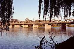
The Grand River Bridge, which carries Argyle St. over the Grand River in Caledonia.
|
|
 |
|
| Coordinates: 42°56′N 79°53′W / 42.933°N 79.883°WCoordinates: 42°56′N 79°53′W / 42.933°N 79.883°W | |
| Country |
|
| Province |
|
| Established | 1800 (County) |
| Restructured | 1974 (Regional Municipality of Haldimand-Norfolk) |
| Amalgamated | 2001 (Single-tier municipality) |
| Government | |
| • Mayor | Ken Hewitt |
| • Governing Body | The Council of Corporation of Haldimand County |
| • MPs | Diane Finley (Con) |
| • MPPs | Toby Barrett (Con) |
| Area | |
| • Land | 1,251.57 km2 (483.23 sq mi) |
| Population | |
| • Total | 44,876 |
| • Density | 35.9/km2 (93/sq mi) |
| Time zone | EST (UTC-5) |
| • Summer (DST) | EDT (UTC-4) |
| Postal code span | N0A, N1A, N3W |
| Area code(s) | 519, 226, 905, 289, 365 |
| Website | www.haldimandcounty.on.ca |
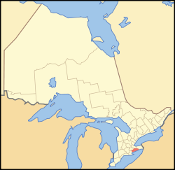
Haldimand is a rural city-status single-tier municipality (but called a county) on the Niagara Peninsula in Southern Ontario, Canada, on the north shore of Lake Erie, and on the Grand River. Municipal offices are located in Cayuga.
Haldimand's history has been closely associated with that of the neighbouring Norfolk County. Haldimand was first created as a county in 1800, from a portion of Norfolk. It was named after the governor of the Province of Quebec Sir Frederick Haldimand. In 1844 the land was surrendered by Six Nations to the Crown in an agreement that was signed by the vast majority of Chiefs in the Haldimand tract. The two counties were separate until 1974, when they were reunited as the Regional Municipality of Haldimand-Norfolk.
In 2001, the counties were separated again, but the lower-tier municipalities from the former Haldimand-Norfolk were merged into two single-tier municipalities. Although they both retained the name "county" for historical reasons, each is governed as a single municipality without lower-tier governments. Haldimand was formed through the amalgamation of the former Towns of Haldimand and Dunnville, and the eastern half of the City of Nanticoke.
Beginning in February 2006, a land dispute by native protesters began near Caledonia over a housing development being built on the outskirts of town, which members of the nearby Mohawk Six Nations people claim is rightfully their land.
The population centres in Haldimand are Caledonia, Dunnville, Hagersville, Jarvis and Cayuga. Part of the Six Nations Reserve is within the geographic area of Haldimand County, but is independent of the county. Most of Haldimand is agricultural land, although some heavy industry, including the Nanticoke Generating Station, is located here.
...
Wikipedia
