Franklin County, Maine
| Franklin County, Maine | |
|---|---|

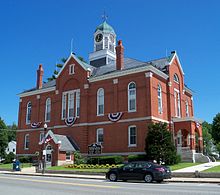
Franklin County Courthouse
|
|
 Location in the U.S. state of Maine |
|
 Maine's location in the U.S. |
|
| Founded | May 9, 1838 |
| Named for | Benjamin Franklin |
| Seat | Farmington |
| Largest town | Farmington |
| Area | |
| • Total | 1,743 sq mi (4,514 km2) |
| • Land | 1,697 sq mi (4,395 km2) |
| • Water | 47 sq mi (122 km2), 2.7% |
| Population | |
| • (2010) | 30,768 |
| • Density | 18/sq mi (7/km²) |
| Congressional district | 2nd |
| Time zone | Eastern: UTC-5/-4 |
| Website | www |
Franklin County is a county located in the state of Maine, in the United States. As of the 2010 census, the population was 30,768, making it the second-least populous county in Maine. Its county seat is Farmington. The county was established on May 9, 1838 and named for Benjamin Franklin.
According to the U.S. Census Bureau, the county has a total area of 1,743 square miles (4,510 km2), of which 1,697 square miles (4,400 km2) is land and 47 square miles (120 km2) (2.7%) is water.
As of 2015 the largest self-reported ancestry groups in Franklin County, Maine are:
As of the census of 2000, there were 29,467 people, 11,806 households, and 7,744 families residing in the county. The population density was 17 people per square mile (7/km²). There were 19,159 housing units at an average density of 11 per square mile (4/km²). The racial makeup of the county was 97.96% White, 0.24% Black or African American, 0.37% Native American, 0.43% Asian, 0.02% Pacific Islander, 0.17% from other races, and 0.81% from two or more races. 0.54% of the population were Hispanic or Latino of any race. 26.3% were of English, 13.8% United States or American, 12.2% French, 9.2% Irish, 7.9% French Canadian, and 5.3% Scottish ancestry according to Census 2000. 95.7% spoke English and 2.9% French as their first language.
...
Wikipedia
