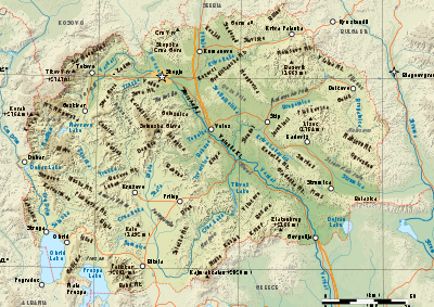
Geography of Republic of Macedonia
 |
|
| Continent | Europe |
|---|---|
| Region | Balkan Peninsula |
| Coordinates | 41°50′N 22°00′E / 41.833°N 22.000°E |
| Area | Ranked 148 |
| • Total | 25,713 km2 (9,928 sq mi) |
| • Land | 96.67% |
| • Water | 3.33% |
| Borders | 766 km |
| Highest point | Mount Korab, 2,764 m |
| Lowest point | Vardar River (near Gevgelija), 50 m |
| Longest river | Vardar, 388 km |
| Largest lake | Lake Ohrid 348 km2 |
| Rank | Name | Height (m) | Height (ft) | Rank | Name | Height (m) | Height (ft) | |
|---|---|---|---|---|---|---|---|---|
| 1 | Mount Korab | 2,764 | 9,396 | 7 | Galičica | 2,288 | 7,507 | |
| 2 | Šar Mountains | 2,747 | 9,012 | 8 | Stogovo | 2,273 | 7,457 | |
| 3 | Baba Mountain | 2,601 | 8,533 | 9 | Jablanica | 2,257 | 7,405 | |
| 4 | Jakupica | 2,540 | 8,333 | 10 | Osogovo | 2,251 | 7,383 | |
| 5 | Nidže | 2,521 | 8,271 | 11 | Mount Bistra | 2,163 | 7,096 | |
| 6 | Dešat | 2,373 | 7,785 | 12 | Plačkovica | 1,754 | 5,754 |
The Republic of Macedonia is a country situated in southeastern Europe with geographic coordinates 41°50′N 22°00′E / 41.833°N 22.000°E, bordering Kosovo and Serbia to the north, Bulgaria to the east, Greece to the south and Albania to the west. The country is part of the wider region of Macedonia and makes up most of Vardar Macedonia. The country is a major transportation corridor from Western and Central Europe to Southern Europe and the Aegean Sea. Macedonia is a landlocked country but has three major natural lakes: Lake Ohrid, Lake Prespa and Lake Dojran. It has a water area of 857 km2, while its land area is 24,856 km2.
Phytogeographically, Macedonia belongs to the Illyrian province of the Circumboreal Region within the Boreal Kingdom. According to the WWF and Digital Map of European Ecological Regions by the European Environment Agency, Macedonia's territory can be subdivided into four ecoregions: the Pindus Mountains mixed forests, Balkan mixed forests, Rhodopes mixed forests and Aegean sclerophyllous and mixed forests.
...
Wikipedia

