Ottawa River
| Ottawa River (Kichisìpi) | |
| Rivière des Outaouais | |
|
The Ottawa River in the autumn
|
|
| Country | Canada |
|---|---|
| Provinces | Quebec, Ontario |
| Source | Lake Capimitchigama |
| - location | Lac-Moselle, La Vallée-de-la-Gatineau RCM, Outaouais, Quebec |
| - coordinates | 47°36′N 75°48′W / 47.600°N 75.800°W |
| Mouth | St. Lawrence River |
| - location | Montreal, Quebec |
| - coordinates | 45°27′N 74°05′W / 45.450°N 74.083°WCoordinates: 45°27′N 74°05′W / 45.450°N 74.083°W |
| Length | 1,271 km (790 mi) |
| Basin | 146,300 km2 (56,487 sq mi) |
| Discharge | for Carillon dam |
| - average | 1,950 m3/s (68,864 cu ft/s) |
| - max | 5,351 m3/s (188,969 cu ft/s) |
| - min | 749 m3/s (26,451 cu ft/s) |
|
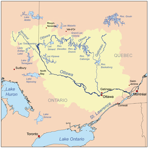
Map of the Ottawa River drainage basin
|
|
The Ottawa River (French: Rivière des Outaouais, Algonquin: Kitchissippi), is a river in the Canadian provinces of Ontario and Quebec. For most of its length, it defines the border between these two provinces. It is a major tributary of the St. Lawrence River.
The river rises from its source in Lake Capimitchigama, in the Laurentian Mountains of central Quebec, and flows west to Lake Timiskaming. From there its route has been used to define the interprovincial border with Ontario.
From Lake Timiskaming, the river flows southeast to Ottawa and Gatineau, where it tumbles over the Chaudière Falls and further takes in the Rideau and Gatineau rivers.
The Ottawa River drains into the Lake of Two Mountains and the St. Lawrence River at Montreal. The river is 1,271 kilometres (790 mi) long; it drains an area of 146,300 square kilometres (56,500 sq mi), 65 percent in Quebec and the rest in Ontario, with a mean discharge of 1,950 cubic metres per second (69,000 cu ft/s).
The average annual mean waterflow measured at Carillon dam, near the Lake of Two Mountains, is 1,939 cubic metres per second (68,500 cu ft/s), with average annual extremes of 749 to 5,351 cubic metres per second (26,500 to 189,000 cu ft/s). Record historic levels since 1964 are a low of 529 cubic metres per second (18,700 cu ft/s) in 2005 and a high of 8,190 cubic metres per second (289,000 cu ft/s) in 1976.
The river flows through large areas of deciduous and coniferous forest formed over thousands of years as trees recolonized the Ottawa Valley after the ice age. Generally, the coniferous forests occur on old sand plains left by retreating glaciers, or in wetter areas with clay substrate. The deciduous forests, dominated by maple, beech, oak and ash occur in more mesic areas with better soil. These primeval forests were occasionally affected by natural fire, mostly started by lightning, which led to increased reproduction by pine and oak, as well as fire barrens and their associated species. The vast areas of pine were exploited by early loggers. Later generations of logging removed hemlock for use in tanning leather, leaving a permanent deficit of hemlock in most forests. Associated with the logging and early settlement were vast wild fires which not only removed the forests, but led to soil erosion. Consequently, nearly all the forests show varying degrees of human disturbance. Tracts of older forest are uncommon, and hence they are considered of considerable importance for conservation.
...
Wikipedia


