Saint-Valery-sur-Somme
| Saint-Valery-sur-Somme | |
|---|---|

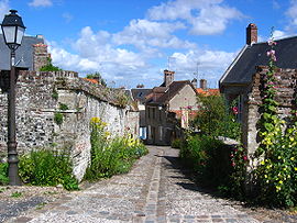
Gaultier Street
|
|
| Coordinates: 50°11′20″N 1°37′50″E / 50.1889°N 1.6306°ECoordinates: 50°11′20″N 1°37′50″E / 50.1889°N 1.6306°E | |
| Country | France |
| Region | Hauts-de-France |
| Department | Somme |
| Arrondissement | Abbeville |
| Canton | Saint-Valery-sur-Somme |
| Intercommunality | Baie de Somme Sud |
| Government | |
| • Mayor (2001–2020) | Stéphane Haussoulier |
| Area1 | 10.5 km2 (4.1 sq mi) |
| Population (2006)2 | 2,822 |
| • Density | 270/km2 (700/sq mi) |
| Time zone | CET (UTC+1) |
| • Summer (DST) | CEST (UTC+2) |
| INSEE/Postal code | 80721 / 80230 |
| Elevation | 1–43 m (3.3–141.1 ft) (avg. 40 m or 130 ft) |
|
1 French Land Register data, which excludes lakes, ponds, glaciers > 1 km² (0.386 sq mi or 247 acres) and river estuaries. 2Population without double counting: residents of multiple communes (e.g., students and military personnel) only counted once. |
|
1 French Land Register data, which excludes lakes, ponds, glaciers > 1 km² (0.386 sq mi or 247 acres) and river estuaries.
Saint-Valery-sur-Somme is a commune in the Somme department. The village is a popular tourist destination because of its medieval character and ramparts, Gothic church and long waterside boardwalk.
The commune is on the Hauts-de-France coast adjacent to the Baie de la Somme and at the mouth of the Somme river. It is 30 kilometres (19 miles) north west of Abbeville and to the west of the battlefields of the Somme. Most of the commune lies adjacent to the sea and the Somme river on the Quai du Romerel, Quai Courbet, Quai Jeanne d'Arc, Quai Blavet and the Quai Perree. The oldest part of the commune lies on the northern coast to the north west of the main settlement. To the south is the main road, the CD940 between Abbeville and Cayeux-sur-Mer.
The history of the commune dates back to before the era of the Roman invasion when it was a small settlement inhabited by Gauls. The Roman invasion encouraged the small hamlet to grow into a small village and after the Romans left France the village soon came under the power of the Franks.
In 611, the monk Gualaric (Walric), also known as Valery, arrived in the area. He installed himself as a hermit on the headland of the site of Leuconaus, now the Cap Hornu.. His virtue and miracles quickly attracted disciples. These disciples formed a primitive abbey. The saint was then buried there in 622 and the Chapelle des marins was erected in 628 by Saint Blimont over his burial place. Clotaire II (King of Neustrie) provided the foundations of the new abbey in 627. The relics of the saint attracted many pilgrims to the abbey which had become known as Saint-Valery. During the 8th and 9th century, the abbey and village were plundered and devastated on several occasions by the Vikings.
...
Wikipedia


