San Ramon, California
| San Ramon | ||
|---|---|---|
| City | ||

View of San Ramon, at the corner of Bollinger Canyon Rd. and San Ramon Valley Blvd. Mount Diablo is in the background on the left.
|
||
|
||
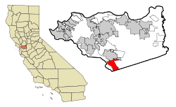
 Location in Contra Costa County and the state of California |
||
| Location in the United States | ||
| Coordinates: 37°46′48″N 121°58′41″W / 37.78000°N 121.97806°WCoordinates: 37°46′48″N 121°58′41″W / 37.78000°N 121.97806°W | ||
| Country | United States | |
| State | California | |
| County | Contra Costa | |
| Incorporated | July 1, 1983 | |
| Government | ||
| • Mayor | Bill Clarkson | |
| • State senator | Steve Glazer (D) | |
| • Assemblymember | Catharine Baker (R) | |
| • United States representatives | Mark DeSaulnier (D) and Eric Swalwell (D) | |
| Area | ||
| • Total | 18.077 sq mi (46.819 km2) | |
| • Land | 18.061 sq mi (46.778 km2) | |
| • Water | 0.016 sq mi (0.042 km2) 0.09% | |
| Elevation | 486 ft (148 m) | |
| Population (2012) | ||
| • Total | 73,927 | |
| • Density | 4,100/sq mi (1,600/km2) | |
| Time zone | Pacific (UTC-8) | |
| • Summer (DST) | PDT (UTC-7) | |
| ZIP codes | 94582, 94583 | |
| Area code | 925 | |
| FIPS code | 06-68378 | |
| GNIS feature IDs | 1656275, 2411805 | |
| Website | www |
|
San Ramon is a city in Contra Costa County, California, United States, located 34 miles east of San Francisco, and within the San Ramon Valley. San Ramon's population was estimated as 76,134 in mid-2015 by the US Census Bureau, making it the 4th largest city in Contra Costa County, behind Richmond, Concord and Antioch.
San Ramon is home to the headquarters of Chevron, 24-Hour Fitness, the West Coast headquarters of AT&T Inc., The Global Software Center of GE, as well as the San Ramon Medical Center. Major annual events include the Art and Wind Festival on Memorial Day weekend and the Run for Education in October.
On April 24, 2001, San Ramon received the title Tree City USA.
San Ramon is adjacent to Danville, California, to the north and Dublin, California, to the south. Unincorporated county lands border San Ramon to the east and west. It is located around 500 feet (150 m) above sea level. Mount Diablo flanks the city to the northeast and is prominently visible from almost all parts of the city. The Las Trampas Regional Wilderness borders San Ramon's extreme northwest, at the northern end of Bollinger Canyon. The smaller Bishop Ranch Regional Preserve straddles San Ramon's western border, located approximately between Interstate 680 and the Alameda County line.
...
Wikipedia


