Santo Tomas, Pangasinan
| Santo Tomas | ||
|---|---|---|
| Municipality | ||
 |
||
|
||
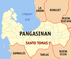
 Map of Pangasinan showing the location of Santo Tomas |
||
| Location within the Philippines | ||
| Coordinates: 15°42′43″N 120°35′05″E / 15.71194°N 120.58472°ECoordinates: 15°42′43″N 120°35′05″E / 15.71194°N 120.58472°E | ||
| Country | Philippines | |
| Region | Ilocos (Region I) | |
| Province | Pangasinan | |
| District | 5th district of Pangasinan | |
| Founded | February 10, 1908 | |
| Barangays | 10 | |
| Government | ||
| • Mayor | Timoteo Salazar Villar III | |
| • Vice Mayor | Wilfredo Pescador | |
| • Electorate | 7,740 voters (2016 election) | |
| Area | ||
| • Total | 12.99 km2 (5.02 sq mi) | |
| Population (2015 census) | ||
| • Total | 15,022 | |
| • Density | 1,200/km2 (3,000/sq mi) | |
| Time zone | PST (UTC+8) | |
| ZIP code | 2426 | |
| 015540000 | ||
| IDD : area code | +63 (0)75 | |
| Income class | 5th municipal income class | |
| Revenue | ₱ 8,198,442.30 (2016) | |
| Poverty incidence | 13.01 (2012) | |
Santo Tomas is a 5th class municipality in the province of Pangasinan, Philippines. According to the 2015 census, it has a population of 15,022 people.
The town's principal products are palay, yellow corn, coconut, tobacco, poultry and livestock.
Santo Tomas is politically subdivided into 10 barangays.
The 1973 St. Thomas Aquinas Parish (F-1973) Church (Barangay Santo Domingo) is under the Vicariate of Sacred Heart (Vicar Forane is Father Hurley John S. Solfelix. Its Feast Day is January 28 and Parish Priest is Father Alejandro T. De Guzman, Vicariate of Sto. Tomas de Aquino, of theRoman Catholic Archdiocese of Lingayen-Dagupan. As a parish, Santo Tomas was erected on March 15, 1974 by Archbishop Federico Limon consecrated the Church on March 15, 1974, since before, Santo Tomas Church was merely a "visita” or chapel of Alcala, Pangasinan, while the town was a barrio of Alcala (from 1898 until the 1901 fusion with Alcala), with former name of Arango (“inarang”, fresh water shells at Agno River).
Before 1898, Santo Tomas was a barrio of Alcala. Arango was its name as a barrio, Such a name derived from “inarang”, a name given to the fresh water shells which abound near the bank of the Agno river. Santo Tomas was recreated as a town in 1908.
On February 11, 2008, during first Corn Festival of the centennial celebration, Santo Tomas got the Guinness World Records certificate for longest barbecue (3,803.96 metres (12,480.2 ft)). Residents grilled 93,540 glutinous corn on the 1,559 metres (5,115 ft) long grills (each interconnected grill measured 2.4 meters), traversing its 10 barangays. Santo Tomas' longest barbecue record beat the previous record of 1,493.2 metres (4,899 ft) set in Montevideo, Uruguay (grilled red meat).
On February 11, 2009, Santo Tomas' Second Corn Festival's 200-meter (stretch of the street) corn grill was held for its 101st founding anniversary. at it previously held its 2007 Santo Tomas Corn Festival.
...
Wikipedia


