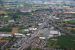
Sint-Pieters-Leeuw
| Sint-Pieters-Leeuw | |||
|---|---|---|---|
| Municipality | |||
 |
|||
|
|||
| Location in Belgium | |||
| Coordinates: 50°47′N 04°15′E / 50.783°N 4.250°ECoordinates: 50°47′N 04°15′E / 50.783°N 4.250°E | |||
| Country | Belgium | ||
| Community | Flemish Community | ||
| Region | Flemish Region | ||
| Province | Flemish Brabant | ||
| Arrondissement | Halle-Vilvoorde | ||
| Government | |||
| • Mayor | Luc Deconinck (N-VA) | ||
| • Governing party/ies | N-VA, CD&V | ||
| Area | |||
| • Total | 40.38 km2 (15.59 sq mi) | ||
| Population (1 January 2016) | |||
| • Total | 33,512 | ||
| • Density | 830/km2 (2,100/sq mi) | ||
| Postal codes | 1600-1602 | ||
| Area codes | 02 | ||
| Website | www.sint-pieters-leeuw.be | ||
Sint-Pieters-Leeuw (Dutch pronunciation: [sɪnt ˌpitərs ˈleːu̯], French: Leeuw-Saint-Pierre) is a Dutch-speaking municipality of Belgium located in the province of Flemish Brabant (Flemish Region).
The municipality comprises the towns of Oudenaken, Ruisbroek, Sint-Laureins-Berchem, Sint-Pieters-Leeuw proper and Vlezenbeek. Sint-Pieters-Leeuw is located just outside the Brussels-Capital Region, in the Payottenland. The municipality is a blend of parks, castles, meadows and gardens with the Coloma park as its green heart.
On December 31, 2012, Sint-Pieters-Leeuw had a total population of 32,659. The total area is 40.38 km² which gives a population density of 808 inhabitants per km². It is a mostly residential community with largely preserved rural areas and some industrial zones.
The municipality is one of the largest municipalities in Flemish Brabant. The rural settlement grew into a major residential and professional community. Sint-Pieters-Leeuw has a lengthy history behind it.
The oldest document dates back to the 9th century and is a deed of donation by 'dame Angela', a noblewoman from Brabant, in which reference is made to a 'domain' of seven miles in length and one mile in width with a parent church and 9 subsidiary churches', donated to the chapter of Saint Peter in Deutz, Cologne.
...
Wikipedia


