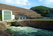
South Holston Dam
| South Holston Dam | |
|---|---|

South Holston Dam
|
|
|
Location of South Holston Dam in Tennessee
|
|
| Official name | South Holston Dam |
| Location | Sullivan County, Tennessee, United States |
| Coordinates | 36°31′24″N 82°5′20″W / 36.52333°N 82.08889°WCoordinates: 36°31′24″N 82°5′20″W / 36.52333°N 82.08889°W |
| Construction began | February 16, 1942 |
| Opening date | November 20, 1950 |
| Operator(s) | Tennessee Valley Authority |
| Dam and spillways | |
| Impounds | South Fork Holston River |
| Height | 285 feet (87 m) |
| Length | 1,600 feet (490 m) |
| Reservoir | |
| Creates | South Holston Lake |
| Total capacity | 765,000 acre·ft (944,000 dam3) |
| Power station | |
| Commission date | 1950 |
| Turbines | 1 x 38.5 MW Francis-type |
| Installed capacity | 38.5 MW |
South Holston Dam is a hydroelectric and flood control dam on the South Fork Holston River in Sullivan County, in the U.S. state of Tennessee. It is the uppermost of three dams on the South Fork Holston owned and operated by the Tennessee Valley Authority, which built the dam in the 1940s as part of efforts to control flooding in the Tennessee River watershed. On October 21, 1950 the valve gate closed and water began backing up to create South Holston Reservoir. Work began on the dam in December 1941, but in November 1942, the War Production Board requested that the operation be suspended because of a shortage of critical materials. Work did not resume until July 1, 1947. The dam now impounds the South Holston Lake of 7,550 acres (3,060 ha), which extends northeastward across the Tennessee-Virginia state line.
South Holston Dam is located 50 miles (80 km) above the South Fork Holston River's confluence with the North Fork Holston River (which forms the Holston River proper). The dam site is situated in an area where the river descends out of the Appalachian Mountains and enters the upper Holston Valley. The dam and the Tennessee half of its reservoir are surrounded by the Cherokee National Forest, and the Virginia half of the reservoir is surrounded by the Jefferson National Forest. The reservoir includes parts of Sullivan County in Tennessee and Washington County in Virginia. The city of Bristol straddles the Tennessee-Virginia border a few miles northwest of South Holston Dam.
South Holston Dam is an earth-and-rock dam 285 feet (87 m) high and 1,600 feet (490 m) long, and has a generating capacity of 38,500 kilowatts. The dam's fixed-crest morning glory spillway has a maximum discharge of 116,200 cubic feet per second (3,290 m3/s). South Holston Lake extends northeastward for 24 miles (39 km) into southwestern Virginia, with 168 miles (270 km) of shoreline and a storage capacity of 765,000 acre·ft (944,000 dam3), of which 252,757 acre·ft (311,771 dam3) is reserved for flood control. The reservoir's operating levels vary by about 23 feet (7.0 m) in a typical year.
...
Wikipedia

