Tiptonville, Tennessee
| Tiptonville, Tennessee | |
|---|---|
| Town | |

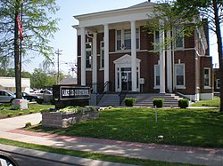
Lake County courthouse in Tiptonville
|
|
 Location in Lake County and the state of Tennessee. |
|
| Coordinates: 36°22′39″N 89°28′34″W / 36.37750°N 89.47611°WCoordinates: 36°22′39″N 89°28′34″W / 36.37750°N 89.47611°W | |
| Country | United States |
| State | Tennessee |
| County | Lake |
| Established | 1857 |
| Incorporated | 1900 |
| Named for | William Tipton (early settler) |
| Area | |
| • Total | 1.4 sq mi (3.7 km2) |
| • Land | 1.4 sq mi (3.7 km2) |
| • Water | 0.0 sq mi (0.0 km2) |
| Elevation | 299 ft (91 m) |
| Population (2010) | |
| • Total | 4,464 |
| • Density | 1,704.0/sq mi (657.9/km2) |
| Time zone | Central (CST) (UTC-6) |
| • Summer (DST) | CDT (UTC-5) |
| ZIP code | 38079 |
| Area code(s) | 731 |
| FIPS code | 47-74540 |
| GNIS feature ID | 1272690 |
| Website | tiptonville.org |
Tiptonville is a town in and the county seat of Lake County, Tennessee. Its population was 2,439 as of the 2000 census and 4,464 in 2010, showing an increase of 2,025. It is also home to the Northwest Correctional Complex, a maximum security prison, known for once housing mass murderer Jessie Dotson, Jr.
Tiptonville was established in 1857, but was not incorporated until 1900. It was designated the county seat when Lake County was created in 1870.
Tiptonville was the scene of the surrender of Confederate forces at the end of the 1862 Battle of Island Number Ten in the American Civil War. The monument for this battle is located on State Route 22 approximately three miles north of Tiptonville, since the island itself, the focal point of the battle, has been eroded away by the flow of the Mississippi River and no longer exists.
Tiptonville is located at 36°22′39″N 89°28′34″W / 36.37750°N 89.47611°W (36.377610, -89.476022), on a small rise known as the Tiptonville Dome and within the New Madrid Seismic Zone. The Mississippi River is to the west and north, the Kentucky Bend is to the north, and Reelfoot Lake is to the east.
According to the United States Census Bureau, the town has a total area of 1.4 square miles (3.6 km2), all land.
...
Wikipedia
