Ottawa West—Nepean
|
|
|||
|---|---|---|---|

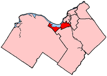
Ottawa West—Nepean in relation to other electoral districts in Ottawa (2003 boundaries)
|
|||
| Federal electoral district | |||
| Legislature | House of Commons | ||
| MP |
Liberal |
||
| District created | 1996 | ||
| First contested | 1997 | ||
| Last contested | 2015 | ||
| District webpage | profile, map | ||
| Demographics | |||
| Population (2011) | 111,881 | ||
| Electors (2015) | 81,646 | ||
| Area (km²) | 71 | ||
| Pop. density (per km²) | 1,575.8 | ||
| Census divisions | Ottawa | ||
| Census subdivisions | Ottawa | ||
Coordinates: 45°21′N 75°47′W / 45.350°N 75.783°W
Ottawa West—Nepean (French: Ottawa-Ouest—Nepean) is a federal electoral district in Ontario, Canada, that has been represented in the House of Commons of Canada since 1997.
The district includes the neighbourhoods of Shirleys Bay, Crystal Beach, Rocky Point, Bayshore, Britannia, Britannia Bay, Lincoln Heights, Whitehaven, Glabar Park, Queensway, Highland Park, Kenson Park, Redwood, Graham Park, Qualicum, Leslie Park, Briargreen, Centrepointe, Woodroffe, Bel-Air Park, Bel-Air Heights, Braemar Park, Copeland Park, Navaho, City View, Ryan Farm, Skyline, Fisher Heights, Parkwood Hills, Carleton Heights, Fisher Glen, Borden Farm, Crestview, Meadowlands, Highland Park, Woodpark, and the western half of Carlington in the City of Ottawa.
...
Wikipedia
